---------------------------------------
THE BOUNDARY PROJECT
multi-disciplinary
2013
--------------------------------------
The Boundary Project is a new collaboration in 2013 with Bob Levene. The collaboration began as a 9 day, 67 mile walk around Sheffield's metropolitan boundary, where both artists live. The project was documented by parallel blogging over the course of the walk.
The project has recently received an A-N New Collaborations bursary to support a series of conversations with cross-disciplinary academics.
We are currently building a wordpress site to host both blogs. Until then, my entries can be found below and Bob's can be found here
There is a short video shot at the most westerly point of our circular pilgrimage which can be viewed here
--------------------------------
DAY 1 - BORDERING
20th January 2013
--------------------------------
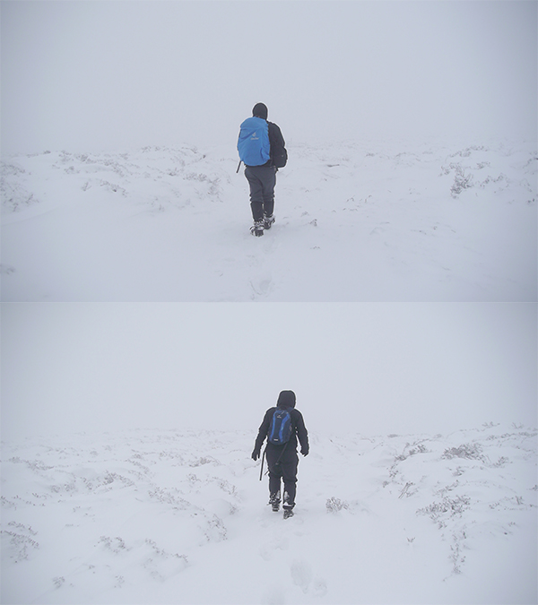
I've been planning a circular journey around the metropolitan boundary of Sheffield with Bob Levene for a while. We both live there so it makes sense. We've been mulling it over for a while - how, when, why, which direction, whether to take a pencil or a raft of recording equipment etc. We haven't given it a name yet because we don't really know what it is, but since the first leg of the journey on Monday I've been turning over the word 'bordering'.
We'd set our starting point (the 'Welcome to Sheffield' sign about 7 miles out of town on the A57) and time (as close to the 7.53 a.m 'sunrise' as possible) but didn't take deep snow and related transport system meltdown into account. We eventually got to the start around 10.30, thanks to a man celebrating his birthday by taking his 1977 Land Rover out for a spin in the snow.
In some ways the extreme weather made any kind of creative musing difficult, distracting, even irrelevant, but I definitely went home thinking differently about what we'd set out to do, and that's at least partly the point I think - action as a catalyst for thought, rather than vice versa.
We trudged and waded about 5 miles in 4 hours, and came out onto the all but deserted road above Ringinglow. We flagged down the first vehicle that passed, before realizing it was a Mountain Rescue Land Rover and waving it on (things weren't quite that bad), and soon got a lift back into town with some friendly snowboarders.
It was a good way to start the journey. The notion of pilgrimage is one we've been discussing, and on that level the blizzard conditions and absence of other people was entirely appropriate, though Im not sure why. It made me feel that we were physically and emotionally placing ourselves at the edge of civilization in a way that wouldn't have been the case otherwise.
That said, I'm looking forward to things being a touch more civilized next time we go out.
You can have a look at Bob's version of events here.
---------------------------------------------------
DAY 2 - DISPUTED BOUNDARIES
27th January 2013
---------------------------------------------------
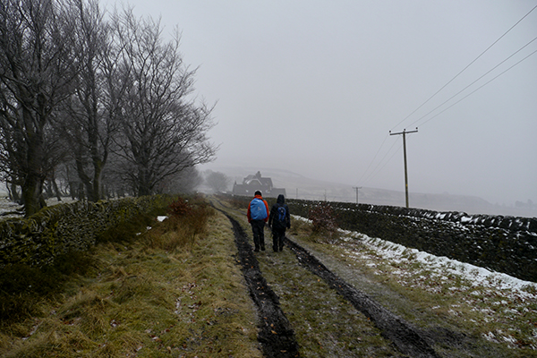
With last week's snows dripping away, and a week to reflect, I was keen to get back out into what promised to be marginally less apocalyptic conditions.
Kindly dropped off this time by less of a stranger (thanks Jade!), we stood briefly in the howling wind at about 9.30 a.m, looking down on Sheffield, before starting out in the other direction on an icy Ringinglow road.
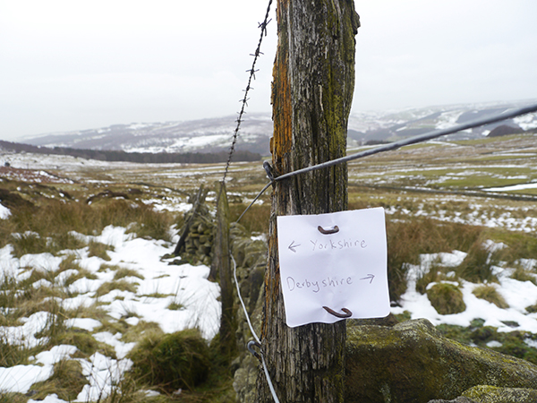
The history of Sheffield's metropolitan boundary is convoluted and not without incident - an article from 1967 talks about 'a vociferous army of 650 'Hands off North Derbyshire!' protestors' descending on Parliament. None of that for us, fortunately, but it didn't take much research into the minutiae of how, when and by whom these lines were decided to leave me wondering at the amounts of time and energy invested in such things all around us.
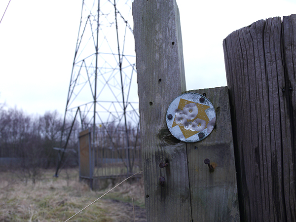
Given a bit more visibility and less risk of disappearing in a snowdrift, we were able to be a bit more meticulous about actually following the boundary line. It tends to follow landmarks of some description - a road here, a wall, or a river there - but it does make the odd seemingly arbitrary diversion. At one point it goes into a car park and then back out again over a wall. A bit later it turns off a main road onto a deserted track, to go round a nondescript mound and back onto the road. Trying to imagine how such an irregularity could occur, I had a brief mental vision of chanting mobs with placards facing off in open moorland.
We talked about how following this particular boundary made us to some extent oblivious of other boundaries, particularly those we were crossing between private and public terrain. I wonder how we will negotiate this as ownership of land becomes more actively policed in the urban areas closer to the city. Such musings also bring to mind the famous 1932 Kinder Trespass, a worthwhile reminder that it hasn't been that long since we had a right to any of this.
The weather got steadily worse through the day, lashing rain and stinging wind mostly, but we clambered out onto the road just down from Owler Bar roundabout in the fading light, just enough time for the last half a cheese sandwich before the bus.
Here's Bob's version.
------------------------------------------------
DAY 3 - HINTER WONDERLAND
4th February 2013
------------------------------------------------
Last time I made a long journey in the name of art, it was down the St Michael's ley line from it's centre point at Avebury in Wiltshire to it's end at Carn Les Boel in Cornwall (see 'Taking the Michael'). It was only at the very end of that journey that the notion of pilgrimage was raised at all, and it seemed to resonate strongly with what we were doing, so I've been keen since to make a journey with that idea at it's root from the beginning. I wasn't convinced that a pilgrimage could end at it's starting point, though, so I looked it up in the dictionary:
'any long journey, especially one undertaken as a quest or for a votive purpose, as to pay homage.'
So then I had to look up votive:
'offered, given, dedicated, etc., in accordance with a vow'
I don't feel that the description quite covers my own feelings about the nature of pilgrimage, but fortunately, it does seem to validate this journey in those terms. As a result, I set out with a new sense of familiarity towards the day ahead.
Both with coincidental new haircuts and jackets (synchronicity with fellow travellers is a symptom of pilgrimage, apparently) we were quickly rewarded with a lovely spot under a tree by a stream to enjoy the first actual sunrise of the journey so far. The stream - Totley Brook - marks the boundary, and we were set to follow it, or a tributary of it, for large parts of the day.
The overarching theme of the day for me was a much stronger sense of travelling through a hinterland between urban and rural. The boundary line tends to take in all built-up areas, so there's quite often a strong visual sense of where one begins and the other ends, but actually moving through it the delineation is much more blurred. It's a zone characterized by the fallout and detritus of the city where the country doesn't quite begin, and no-one's really very interested in it. It's also mostly ugly and generally dispiritng. Our rambling costumes and maps were feeling quite out of place.
Still, later in the afternoon, we came back out into beautiful woodland near Gleadless, and it felt the day had come full circle. It would have been a lovely way to finish there, but it wasn't to be. Instead we got lost, and clambered helplessly out of a badly fly-tipped section of the woods onto scrubby farmland to the sound of people arguing and dogs barking on the nearby estate. We eventually came out on White Post lane, and the journey back into town afforded me the first-in-a-lifetime experience of eating dhal on a tram.
You can read about Bob's day here.
---------------------------------------------------
DAY 4 - PROGRESS OF PILGRIMS
11th February 2013
---------------------------------------------------
Picking up where we left off last time - the last tram stop out of Gleadless - we quickly crossed the second golf course of the journey, this time deserted, to follow a footpath through a wood but quickly got stuck with a decision of whether to go into and through someone's garden in order to get to the road. I decided not to - I don't mind wandering across farmers' fields but somehow would rather avoid gardens. Musing on why this should be, I wondered if it is infringement of personal space that informs my sense of what is and isn't acceptable, and how far that space can be presumed to extend.
With this is mind we started, not for the first time, to consider how the land is divided around us as we walk, and when you do that, the idea of public footpaths as connecting arteries between large blocks of privately owned land is unavoidable. You begin to look at the meagre amounts of space afforded to walking for pleasure, and wonder how quickly these rights could be taken away. I have no idea what sort of laws protect footpaths, and at one point in the morning we stopped on the brow of a hill on a path between two fields and had a discussion about how this journey is at once bringing us closer to an understanding of our surroundings, yet also serving to lay bare greater complexities.
Today I felt more keenly aware of historical land use. As we move from the South to the East side of the city, there is a growing industrial legacy to the landscape. Passing through Twelve Acre woods near Halfway, (presumably) mill buildings have collapsed into the river, and at one point a steel girder has fallen across to create a disruption to the flow. Further on we pass through an area of somehow unnatural-seeming head high rushes, which we find out is known locally as 'Blackwater' and is the site of a pit closed in 1956.
Rother Valley Country Park is a sequence of watersports lakes on the site of a former quarry, and is about as joyless as I'm imagining our looming slog up 6 miles of the M1 will be in a couple of weeks, but I don't mean this to be a review of the post-industrial leisure landscape of East Sheffield, so I'll keep it brief - just to mention that it exists.
We finish the day's walk with the most impressive bit of actual wasteland so far and out onto a main road that takes us to a bus stop in Beighton, a part of Sheffield I had previously never heard of, and back into town on the 32.
It should finally be noted that today will henceforth be known as 'Bob's Big Dog Day', having been harangued by an uncanny number of large dogs. Brief research reveals that encounters with black dogs have apparently been widely reported by travellers on the Santiago de Compostela pilgrim route. The consensus appears to be that these supernatural encounters may represent some kind of turmoil to be overcome in order to continue the journey. You can see what, if anything, Bob has to say about that here.
-----------------------------------------------
DAY 5 - LEISURE WALKING
3rd March 2013
-----------------------------------------------
Before we started this journey, we made a decision that we would walk during the week, treating the activity as a working day. I hadn't really considered the ramifications of that decision until we set out this time on a Sunday.
For a start I made it to the relevant bus stop in town for 10 rather than 8, where there was no-one rushing round me on their way to work. I've had a vague but pervasive sense of otherness setting out on these walks on Monday mornings that was absent today, as, on the weekend, we are indistinguishable from other leisure seekers. Except, of course, that we're working.
The first section of the walk went through the Woodhouse Washlands Nature Reserve, a small tract of land either side of the River Rother that forms the boundary. We met a volunteer for the Trust, who told us that since the boundary is the river, if the river changes course, so does the boundary. This is borne out by a public artwork marking where the river ran in the 1820s, some 200 metres across the flood plain. Large sections of the boundary so far have followed water courses, and it strikes me that the same is true of global borders. I wonder if this has ever been cause for dispute between countries and how such a scenario would be resolved.
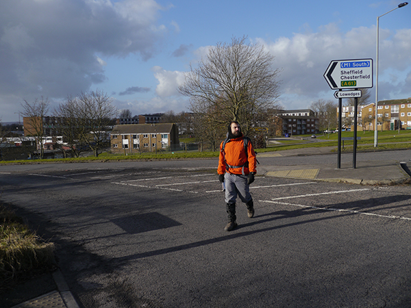
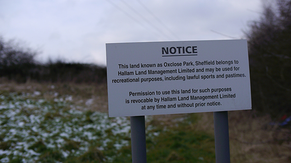
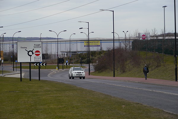
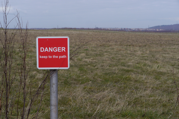
Over a main road and we came onto Orgreave Common. I found it disarming that a place with such volatile associations in recent social history should be so numbingly nondescript (it was the site of the Battle of Orgreave - the famous clash between police and miners in 1984) but of course there will be some happier to see the site quietly erased. So it is that the entrance is dominated by a heavy-handed list of possible fines available for various activities courtesy of the site contractors, who, on the other side of the common, are starting the process of turning the large open space into swathes of characterless new housing.
Entering the M1 corridor the landscape is increasingly dominated by commerce and, equally, the failure of commerce. Although there are giant warehouses, hotels, car parks and supermarkets all around us, there are just as many empty enterprise parks and overgrown concrete platforms behind mouldering advertising hoardings. Moving through these spaces on foot, that aren't meant for leisure or for walking, is an uneasy pleasure, but a pleasure nonetheless. Saying that, I think it would feel very different on a weekday, a theory we can put to the test next time.
Bob's account is here.
--------------------------------
DAY 6 - THE ROADS
6th March 2013
--------------------------------
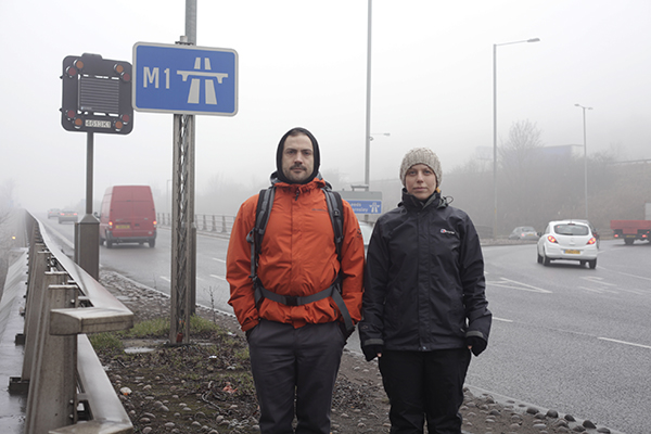
This has been the section of the walk that seems to have hung most heavily over the journey so far - we've always known we'd have to do it but never known quite how it would be. In the event, walking 6 miles up the M1 wasn't half as bad as we'd been imagining.
Of course, we weren't ever going to go up the hard shoulder or anything, and infact, the boundary line isn't the road itself but sits tight to the Rotherham side until it curves back west above Chapeltown on the A616.
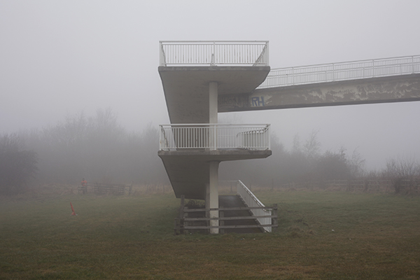
One of the first things we had to do was to traverse it during morning rush hour on a high, long and narrow footbridge, the thick fog giving the scene an air of surreal grandeur. It felt somehow reminiscent of the opening of Herzog's 'Aguirre, Wrath of God', although hopefully I won't go insane and wind up rafting down the River Don with a clutter of monkeys by the end of this journey. If anyone is interested, by the way, the difference between fog and mist is that the visibility in fog is less than one kilometre.
The motorway has a life of it's own. It's a microclimate, supremely unaffected by anything happening around, the only sign of external factors being the changing volume of traffic. The M1 is the oldest motorway in existence, so, for interest, I glanced at a clip from 1959 of the road's designer, Sir Owen Williams, where he makes the now startling claim that "...there is no other greater effort being made in the world comparable to this.". Despite it's antiquity, the road has absorbed nothing of it's locality (place names notwithstanding), nor will it.
The first thing I associate with motorways is the noise but it really didn't seem that loud, especially if the road is above you. We spent the morning weaving over and under and in and out of fields and patches of scrubby woodland, with occasional clear views of the road itself, and periodic piles of tyres and snack food packaging. All in all it wasn't an unpleasant experience, and actually the A-road we came onto was much more of a heads-down trudge.
Because of that, we covered the ground we thought we might cover much more quickly and were able to carry on into Grenoside woods. We quickly climbed through woods and across streams, terrain more reminiscent of the earlier parts of the journey. It was a pleasant and unexpected way to finish the day, knowing that we have really pretty much left heavy population behind now for the rest of the journey.
Bob's account of the day is here.
--------------------------------------------------
DAY 7 - BACK TO THE COUNTRY
13th March 2013
--------------------------------------------------
On the map, today's walk didn't look anything like as difficult or long as the last one, setting off from Oughtibridge, from where the boundary snakes up the River Don towards Stocksbridge to join established paths and roads later on.
We started out having to hop over the perimeter wall of a new upmarket housing development and into beautiful woodland climbing steeply from the riverbank. There was no marked access to it or through it but plenty of impromptu paths. These faded away as the woods became less picturesque, and we were soon crashing through brambles between a railway and a sewage plant. It was hard and slow going and towards the end of the morning we had to turn back for the first time on the whole journey.
We had followed a path of sorts over a home-made bridge into farm fields, and then traversed the bank of the river for a few hundred metres until a large tree stuck right out into the flow. It was either that or a closed off field with 4 horses in it which we would have had to climb out of directly in front of the farmhouse. We hung around for a bit to see if anyone would come out so we might reason with them, but they didn't, and as we trudged back down the edge of the field, I looked back to see a figure standing still with hands on hips, which I have come to recognize as a universal get-off-my-land-before-i-have-to-say-or-do-anything stance.
From here the boundary strikes back east for a couple of km, which we had failed on the map to notice was an extremely steep hill, after which we were very ready for lunch on top of an escarpment from where we could look over towards Bleaklow, where we are headed next time.
The afternoon looked easy as it mostly followed the 'Barnsley Boundary Walk'. This is a designated route marked on OS maps in the same green diamonds as the Trans-Pennine Trail, which has seemed to mock us at various points of the journey as we've crossed it's wide gravelly flatness to disappear into another bog or thicket. Actually, it would have been very boring to walk it's full length, but we were quite happy to be following something similar as we had quite a bit of catching up to do.
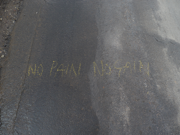
At some point in the recent past, someone has travelled this route with a piece of yellow chalk, writing 'No Pain No Gain' where possible on roads and fence posts. The message seemed increasingly appropriate as we followed diversions through deep farm mud to main roads with no verge and had to draw the line when the road the path supposedly joins was actually a flyover up above our heads. It also seems appropriate, as we move towards the latter stages of our journey, that we are presented with such unexpected challenges, and it wouldn't have felt right to have completed the whole journey without struggling to do so in some way or other. Pilgrimage shouldn't just be about plain sailing, but I hope the next and penultimate leg of the journey isn't too much harder than it looks as we head back into the unpopulated wilderness.
Bob's blog here
-----------------------------------------------
DAY 8 - WILDERNESS AND DEATH
19th March 2013
------------------------------------------------
Day 8 started very early, promising to be a day of superlatives – the highest, most remote, and most westerly part of the boundary. To that list I can now add most dead animals.
In anticipation of a hard day’s walk, combined with the fact that we’re starting an hour and a half’s journey on public transport from the centre of Sheffield, we put our feelers out for a lift, and came up trumps with a friend driving to work in Huddersfield (thanks Tomos!).
As a result we found ourselves looking out over Langsett Reservoir at half past 7 on a cold but sunny spring/winter morning. Still water, creaking pines and birds singing made it feel like a far cry from our starting point a couple of stretches back, trying to cross junction 33 of the M1. We were soon faced with access problems of a different kind though and ended up shinning over a slippery treetrunk that had fallen across the fast-flowing stream of the Little Don. We had to go back across a bit later, and this time had to ford the river ourselves with a single well-placed stone to avoid wet feet for the rest of the day.
This led me inevitably back to thinking about the schools of thought around marks left on the landscape, not for the first time ( see day 5 – the ‘banana skin incident’), and set me to musing as to how we have or haven’t negotiated this sigh-worthy yet unavoidable aspect of this kind of practice.
I’ll have to leave that for next time, though, as my thought pattern was interrupted by the sight of a lone black rabbit. Having never seen such a thing in the wild before I made a note of it in the hope that returning home I would find a host of references to black rabbits in relation to pilgrimage. Sadly the only thing I turned up was the Black Rabbit of Inle, a ghostly figure representing the afterlife in the belief system of the rabbits in Watership Down.
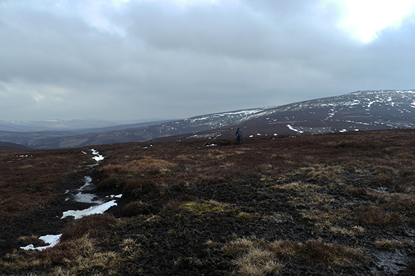
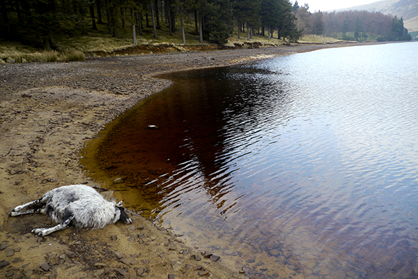
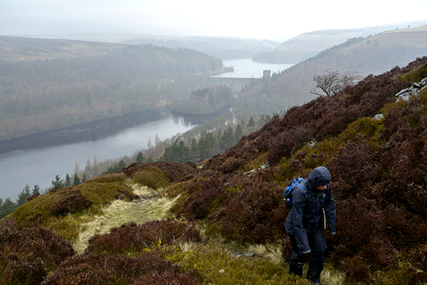
Saying that, death did feature strongly in the rest of the day’s walk, as we passed scraps and piles of bones, feathers and skulls of mainly grouse, crows and sheep along the way. Although none of the carcasses were particularly exotic, it did intensify my feeling of being well beyond the reach of the city, despite being on it’s boundary. We couldn’t see any sign of civilisation whatsoever as we turned back east off the high peat and gritstone expanses of Bleaklow to follow a stream down into the top end of the Upper Derwent valley.
We reached the reservoir in late afternoon and took a break not far (but far enough) from recently dead sheep lying on the bank looking plaintively across the water. It’s peaceful morbidity seemed to sum up a day of space and reflection on what we’ve done and it seemed like a good spot to crack open the hip flask and mentally prepare for the last day of our circumnavigation while we waited for a lift home, for which thanks are due to Katie.
Bob's day is here
------------------------------------------------------------
DAY 9 - THE END AND THE BEGINNING
20th March 2013
------------------------------------------------------------
Setting out from the Visitor’s Centre between the Derwent and Upper Valley reservoirs, it was fitting that we would start the last day from the point at the water’s edge from where we had begun an afternoon long ‘trial run’ in late autumn last year.
Before we’d even got that far though, we found cause to stop and discuss what, if anything, we would have achieved by the end of the day. We spoke about our individual and shared rationales for the project, how we'd envisaged the journey, and how it has progressed. I realised that I had set out with an expectation that, in some way, we would be leaving deliberate physical traces behind us. That did happen a bit at the beginning, but, in retrospect, these attempts were insincere and reductive as a result, and dropped off without discussion.
What seems more interesting as we reach the end of the journey is that those early actions were not steps towards an outcome or resulting artwork, but towards an absence of need for such a thing. I can think of a few possible reasons for this but the main sense I have is of the walk having become an end in itself.
Climbing steeply up the side of the reservoir, with the weather quickly and perhaps appropriately moving towards the blizzard conditions of day 1, I thought for the first time about the end of the journey and more specifically about reaching the starting point on the A57 from the other direction, ending rather than beginning.
We reached the top of the hill where the boundary bears south to follow the line of imposing gritstone outcrops along Derwent Edge with descriptive names like 'Salt Cellar' and 'Cakes of Bread'. After a lunch huddled from the wind and snow behind one of these, and with poor visibility, we had to rely completely on the compass for the first time since day 2, as the boundary line strikes out across open moorland towards where Strines Moor slopes down towards the road at Hollow Meadows. We were looking for what are marked on the map as 'Boundary Stones' and appear as a row along the line of the boundary. What isn't clear on the map is whether they exist to mark the boundary, which would be a first, or are convenient landmarks so named after the boundary was made. The former turned out to be the case and it seemed an odd coincidence that the only section of the whole 67 mile boundary that is actually marked as such should be the very last couple of miles.
During this final stretch conversation inevitably turned back to the actuality of completing our journey, what it has been and what we'll take away from it. I remembered a conversation I had a couple of years ago with Cornish artist, folklorist and sometime pilgrim Steve Patterson, who was talking from his own experience: “At the end of a pilgrimage, it can be a bit depressing. There’s no grand realisation, no flash of light – it’s just you, the place, and the end of the journey. When you reach the end, though, it’s then that your own pilgrimage really begins.”
This struck a chord with me at the time, and still does. I like the simple humdrum truth of it, but also the emphasis on reflection and development over specific outcomes. It creates a cause and effect relationship between external and internal landscapes and makes the journey from one point to another contemplative as well as physical, though not necessarily concurrently.
Before we started this journey I wondered, based on the notion that pilgrimage is by definition a linear experience, how these interdependences would shift if the physical journey is a circumnavigation.
I can't really say for sure if this journey has answered this, or any of my questions. It might have done, or it may yet. Either way, it doesn't really matter - I've got plenty of new ones.
Bob's round-up can be found here.
: Day 1
: Day 2
: Day 3
: Day 4
: Day 4
: Day 5
: Day 5
: Day 6
: Day 6
: Day 7
: Day 7
: Day 8
: Day 8
: Day 9
: Day 9